31 Aug. 2020
Tour de France in Moûtiers 16-17 september 2020
Event, News

Pedestrian sports Hiking itinerary
73440 Val Thorens
Ajouter aux favoris
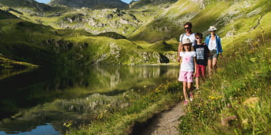
We reach the small lake of Montaulever by following a nice pathway in a magnificent setting appreciated by marmots.
Place of Departure: Val Thorens
Altitude at point of departure: 2300m
Maximum altitude: 2580m
Access for pushchairs: no
Nature of the Ground: track
Large variety of wildlife
From 01/06 to 30/09.
Subject to favorable snow and weather conditions.
Le Lac du Montaulever